Click to zoom …
Walk Details
This walk, with two overlapping routes, is varied with upland, parkland and agricultural land: both start with a moderate fall from Coldwall Farm to the bridge and end with a prolonged uphill stretch through Okeover Park to Martin Hill Farm, level at first, then steeper and thereon a moderate rise.
Read more ...
Route a: Coldwall, Thorpe, Mapleton and Okeover Park
Note: from Coldwall Bridge, this route rises moderately steeply up to the village of Thorpe, then descends/ascends via a steep valley and over several level fields, before descending down to Mapleton.
Leave by the Blore Hall vehicular entrance and walk straight on along the road towards Mapleton.
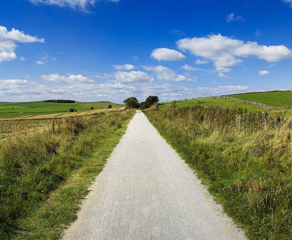
1. Fork left in about 450 yards down the driveway to Coldwall Farm at a ‘public footpath’ signpost. This is part of the Limestone Way with fine views including of Thorpe Cloud.
Go straight through the farm complex and continue along a broad track, descending the valley side. The track sweeps round the hillside before heading for Coldwall Bridge, over the River Dove. Go over the stile at the bottom.
2. Cross the bridge and a stile, then ignoring all footpaths to right and left, rise moderately steeply along a partly surfaced lane towards Thorpe. Bend left in between housing for only 100 yards before turning right at a public footpath sign down a surfaced roadway which soon becomes a narrow footpath below the church. Ignore the stile (R) and instead of bending left with the graveyard wall, bear right down a path, again ignoring in 80 yards another stile (R), as it leads to a very steep drop into the valley. Continue on downhill, and before a footbridge turn right and over a stile, then rise up the steep valley side to a stile (L). Turn right up the lane. Passing a farm entrance, cross the stile(R).
3. Walk diagonally across a large field, passing in the middle a forlorn stile (no wall/fence!). Squeeze through beside a farm gate. Continue in a straight line down this field until you walk alongside a hedge (R), then copse of trees (R).
At the field end, 15 yards to the left of a farm gate, go through a squeezer stile. Bear left towards Spendlane Farm (located on the other side of a road). Do not cross the road in front of the farm but walk along the hedge (L), crossing a watering spot for cattle, to an open gate, then a gate/stile to reach a road. Turn right for 20 yards, then left at a ‘Mapleton and Ashbourne’ sign. Walk in a straight line bearing slightly left down the meadow, past a left-bending hedge, then an acute angle in the hedge, and head straight for the far left corner of the field. Pass through a hedge, walk along a hedge (L) to go through a gap between hedge and wall (R).
Continue on until you bend left through trees, then right alongside trees (R) soon passing through a series of them. Emerge on a path descending diagonally right towards Mappleton and go through a wide gap in a tall hedge. Turn right immediately to descend to a squeezer stile and pass through the churchyard to the reach the road, close to the Okeover Arms. The small 18th Century church has a curious bell dome.
Whether or not refreshed, take the ‘footpath to Dovedale’ over a stile opposite the Arms and bear right across a small field and through a stone squeezer stile/small gate. Turn left on the road to cross the bridge over the R. Dove, then in some 100 yards turn left into parkland.
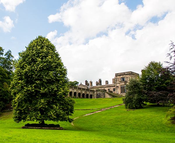
4. Having entered the parkland of Okeover Hall, at a public footpath sign in 150 yards, leave the road to the right to follow the indicated line over close-cropped grass. Okeover Hall and chapel (R) can be seen as you rise steadily to pass a pair of tall trees (L), keeping to the right of a natural depression to head for an isolated building. Go over a stile beside a gate, pass the building and head for a gap in the woodland ahead. Go over a metal ladder stile beside a field gate and continue by the side of a wall (L), keeping the same line up across a meadow towards the angle of a fence/hedge and Martin Hill Farm. From the angle, walk to the right side of a fenced area and bear left to a marked stile.
5. Proceed up towards the farm. Go through a waymarked farm gate and turn right to pass in front of the buildings to another field gate. Bear left to yet another (yellow marked) field gate. Go through it and keep a fairly straight line about 30 yards below a fence (L) to a stile, then cross 2 more fields towards an isolated agricultural building in the left corner. Go through the gate, with post beyond, and walk up the lane, strewn with stones from both side walls, through a metal, then wooden, gate up to the substantial stone Woodhouses Farm.
6. Join a minor road continuing in the same direction, with the tower of Blore Church soon in view. Blore Hall is also seen before a final dip and rise leads to the rear entrance, Car Park C, by the swimming pool.
 Nearest Train (or tube) Station(s):
Derby