- Home
- All Walks · Walking Routes
- Walks by Region
- Walks in the Cotswolds
- Cleeve Hill Walk, Cotswolds
Click to zoom …
Walk Details
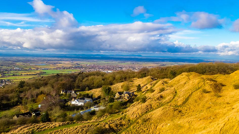
Cleeve Hill, at 1075ft (328m) the highest point of the Cotswolds and part of the last remaining wild common, is a marvellous viewpoint; large areas of the Severn Valley not seen from other routes are in view. A beautifully sited Iron Age hill fort dominates the west facing scarp. Belas Knapp is the finest long barrow in the area.
Combining these features into an excellent circuit linked by lanes and footpaths, much of it being part of the designated Cotswold Way, is a tempting proposition. Comparatively little of the ascent is really steep.
Go over a stile to start up the clear track rising steeply through woodland, waymarked ‘Belas Knapp’, part of the Cotswold Way. After a kissing gate at the top turn left, along the bottom edge of a meadow. Go right at a waymarked ‘Belas Knapp’ sign to rise along the left edge of the same meadow. Go through another waymarked kissing gate at the top, bearing left to stay close to the wall on the left, now rising more gently. Continue through the top edge of woodland to a fork with a waymark on a post. Go right to an old kissing gate and over a stone stile to reach Belas Knapp.
Continue over a ‘Cotswold Way’ marked stile to follow a path along the right edge of a huge meadow. At the far end (waymark and signpost) turn left to follow a farm roadway, rising a little before descending to the sadly abandoned Wantley Farm. The Cleeve Hill communications masts are in view along this section. Turn right at a ‘Cotswold Way’ marked gate to rise steadily towards Cleeve Hill and the masts along a broad track across rough grassland. Pass a waymark on a gatepost. Descend to a waymarked gate at the entrance to Cleeve Common.
Leave the Cotswold Way, turning half left to take a broad track over grass, ignoring paths to left and right, soon passing a trig. point on the left and reaching a stone wall and first views to the west. Turn right to continue close to the wall as far as the masts and their unlovely accretions.
Carry on walking in parallel with the wall for 250 yards or so. There are many tracks on the Common. The best line to the next objective – The Iron Age hill fort – is to follow a narrow path bearing a little to the right, avoiding any descent. The ramparts of the fort are soon in view ahead. After the hill fort the track bears a little to the right, passing close to one of the greens of a golf club; the course occupies a good deal of this end of the hill. There is a Cotswold Way mark on a post.
Stay close to the edge of the scarp to head for the next waymarked post, where there is a superbly placed seat. The hamlet in view below is Nutterswood. Head for the next marker post, with another seat.
Cheltenham and Bishops Cleeve are close below. Continue to another post and seat before bearing right, away from the scarp, to a marker post in 100 yards then a little ascent to pass a waymarked post and reach the top of the hill, with trig. point and orientation table. The extensive views include the Black Mountains of South Wales, the Malvern Hills and much more.
Leave the top by turning right to descend for 50 yards to meet a broad track. Turn left to walk along the top of a valley side as far as a junction with an unsurfaced roadway. Turn sharp right to descend the valley side. Pass the 11th Tee and a green before turning left along a clear path on the east side of the valley, descending gently. Pass old quarry workings, either above or below, but avoid any crossing of the valley bottom.
Several paths head in roughly the same direction, all descending to converge at a waymarked white post, close to woodland. Cross a track, go over a waymarked stile and cross a meadow with a waymark on a post in the middle. Go over a waymarked stile, then another in 40 yards, before turning right to walk beside the high wall guarding Postlip Hall. Continue through gates, across the entrance drive to the Hall, and through more gates to reach a surfaced farm road.
Turn right, uphill to pass the splendid Postlip Hall Farm. The Hall itself is best seen from this lane. The road loses its hard surface. Pass new houses and extensive farm buildings. Go straight ahead at a waymarked junction to descend towards a small valley. As the roadway bends to the right, go through a waymarked gate on the left and keep close to the fence on the right to descend to a gate. Cross a stream on a waymarked footbridge and rise steeply through woodland. Go through a waymarked gate and keep to the left edge of a paddock to a gate/stile.
Join a surfaced lane, going straight on, rising a little. Winchcombe is below, left. Pass above Corndean Hall then, at a road junction in just over ½ mile, bear left. At the next road junction turn right to return to the car parking area in 100 yards.
 Nearest Train (or tube) Station(s):
Cheltenham Spa
Read the Countryside Code before venturing out
Make sure to take a map and compass, and know how to use them before going into our National Parks #BeAdventureSmart
Tips for New Walkers: click here to download (PDF).
Remember to prepare properly before heading out on any type of walk or outdoor activity. Tell people where you are going and what time you are expected back. As Wainwright says "There's no such thing as bad weather, only unsuitable clothing".


