No doubt a picture’s popped up in your head. Maybe something from Skye. Or something from the Highlands. Or the Lake District. Snowdonia. The Yorkshire Dales.

Yes, the Yorkshire Dales.
Proud owner of thirty mountains all its own.
For me, I have to say Pen-y-Ghent would be on my list of contenders. As would Great Gable. And Kirk Fell. And Cairn Gorm. But all for different reasons. Not the reasons that are simply a bunch of numbers. 694m. 899m. 802m. 1245m.

Whilst gaining height on any hill or mountain offers the rewards of breath-taking views, I’ve come to figure that my own favourite mountains are defined more by the experiences I’ve had on them. You know the type of experiences I mean – the ones where the wind blows hard enough to whip you off your feet or the rain comes down by the flood or you manage all four seasons in the space of five minutes or you get caught in a lightning storm… yep.
Now I’m going to throw my own curve ball for one of my favourite mountain days.
The Howgills.
That’s right.
The Howgills

Now officially part of the Yorkshire Dales National Park, this impressive collection of steep-sided, rolling mountains had been something I’d never trekked – we were either further south in the Yorkshire Dales or simply flying past them to the A66 and then adventures in the northern Lake District and, occasionally, Scotland.
But, in April 2016, the Howgills were to become part of our ‘do you remember that day?’ folklore.
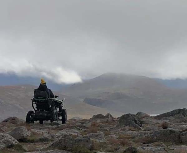
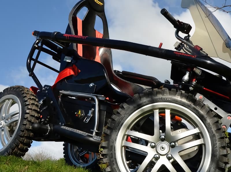
I was now using the TerrainHopper. The previous year we’d travelled coast to coast and thought we should make some sort of long-distance effort an annual affair. This route was going to take us from Semerwater in the Yorkshire Dales to Ullswater and then onto Bassenthwaite.
The plan was to try and go higher when possible and on the first couple of days we’d skirted with climbs as we trekked through to Ribblehead and then over into Dentdale.
But a traverse of the Howgills was the ‘highlight’ of the route.
Sedbergh shivered in the foothills of the cloud-shrouded hills as our party of eight met up. Jonathan Smith, of Where2walk fame, was with us, our mountain guru/Crocodile Dundee type bloke. Rachel Briggs from the Yorkshire Dales National Park Authority had kindly offered her time to experience getting piss wet through with us on a hillside. Judith was there to keep the foul language to a minimum. Sue was with us because she enjoys suffering. Jane was there as backup driver i.e. superhero/mindreader/medic/motivational speaker/conspiracy theorist/hotel locator/baggage transfer/everything else we needed.
And Andy was there to worry about everything. Which is why he collared Jonathan to explain to him he thought the TerrainHopper would struggle to make the traverse of the Howgills all the way to Bowderdale Head. Jonathan agreed. But not for the same reasons. Andy was convinced one of the motors on the ‘Hopper was “playing up.” (Hey, come on… even F1 cars go wrong!)
Jonathan was convinced it was “too bloody wet, too bloody windy and too bloody steep.”
After a meeting which lasted all of two seconds we set off for the summit of Winder. The initial plan was to see if we could get there and then most likely head back into Sedbergh. Jane was given some vague time to wait for us (‘today’) before heading onto Bowderdale Head.

The climb up Winder was steep. Its summit was shrouded in mist and as we made our way up, the rain began to fall. Approaching the trig point, Andy checked his Twitter feed as his phone had chirruped and announced, “Being followed by a poet!” More than one person glanced behind no doubt expecting to see a flamboyant dandy skipping along with parchment and quill.
“I meant on Twitter.”
The summit felt like a big achievement and I welled up. There’s a photo of me somewhere doing just that. I welled up even more when Andy and Jonathan announced we were going to give the traverse our full and undivided attention. From here on in, the adventure was about to get wetter and windier. With absolutely no view and simply incessant rain, we took what seemed like a rollercoaster-type route to the final pull up to Calders.
I think that was the point we figured Andy’s theory about the dodgy motor and Jonno’s theory about it being wet, windy and steep all merged into one. To get up the incline, I needed pushing – and this is a rarity in the TerrainHopper (see the dodgy motor earlier).
But we got to the summit of Calders. The views of the inside of the cloud were underwhelming. And then we reached The Calf.
In many ways, the high point feels like ‘job done’ – but that’s a false sense of security. From here, we still had a journey over ground that would have been perfectly at home in 20,000 Leagues Under The Sea.
Wet… Muddy… Windy… Miserable. It had the lot.

I’m not sure when, but we did change the battery over at some point on the climb to The Calf. The boggy ground was eating the battery up and the second one was tumbling as we squelched along.
Now Andy’s role is to worry.
And when he pushed the ‘Hopper through a particularly boggy section and saw the display reading 7%, he said a few words along the lines of, “Well, I’m proper vexed.” The group got strung out as we ploughed along. Jonathan took me ahead as the battery now read 3% and simply said: “Keep going. Don’t let Andy see it.” Andy led the rest of the group through and said later, “I didn’t need to navigate. I followed your tyre tracks.”
To this day we do not know how we got to the end of the walk and met up with Jane.
With a battery reading 0% and a gaggle of adventurers who were all wetter than an otter’s pocket, we decided that had been a bloody magnificent day.
The Howgills.
Wet.
Windy.
Miserable.
And bloody brilliant.